Over the last few months I’ve been mapping the hiking trails and off street paths of my city, Northampton, Massachusetts, using Open Street Map, a free world map that anyone can edit. My Sundays have often been going out hiking with friends in the Sawmill Hills of Florence, recording my tracks with a GPS. There are miles of paths and every time I go out I discover another new to me path heading off that I mark to map later. I especially enjoy walking through the hills to visit friends on the other side – walking through the woods to a fun destination is the best!
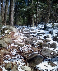
My dream is be able to walk pretty much anywhere on trails and back roads. A couple of weeks ago I walked to my friend’s place in Huntington, Mass. on trails and back roads like this one, which is Spruce Hill Rd in Westhampton. Just the kind of “road” I like:
 All that needs to happen for my dream to be realized is for the many trails and paths that already exist to be mapped – if you have a smart phone with a GPS in it (most do), you can explore the trails near you, and add them to Open Street Map. (For Android, you can use My Tracks).
P.S. 7/12/14: Since writing this post, I discovered the Strava heat map of the Sawmill Hills. Strava compiles all of their customers’ running and biking journeys into one map, allowing you to see where many trails are. You can use it to edit Open Street Map as well.